Continental Welsh Wild West Sportive
From AberCycleFest
- Date Sun 28th May 2023
- Time 08:00
- Location Aberystwyth, Ceredigion
- Price £40.00
- Races 3 races

Event summary
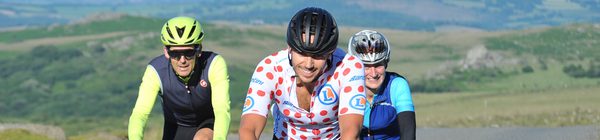
Get ready for an unforgettable cycling experience at the Continental Welsh Wild West Sportive, hosted by AberCycleFest on Sunday, May 28, 2023, in the stunning coastal town of Aberystwyth, Ceredigion. This exciting event caters to cyclists of all skill levels, offering three fantastic ride options: the challenging 'Cawr' and 'Mynach' routes for the seasoned riders, and the more leisurely 'Diafol' ride for those looking to soak in the breathtaking Ceredigion scenery at a relaxed pace.
As part of the week-long AberCycleFest, participants will embark on a journey through some of the most picturesque landscapes in Great Britain, showcasing both famous landmarks and hidden gems. The event begins and ends at the iconic Aberystwyth Bandstand, where all cyclists and volunteers are treated to a complimentary hot meal. Riders will also receive a stylish Continental gym bag, a finisher's medal, and a T-shirt to commemorate their achievement. With fantastic support from volunteers at well-stocked feed stations along the route, this is an event you won’t want to miss! Join us for a day of cycling, camaraderie, and celebration in the heart of Wales!
As part of the week-long AberCycleFest, participants will embark on a journey through some of the most picturesque landscapes in Great Britain, showcasing both famous landmarks and hidden gems. The event begins and ends at the iconic Aberystwyth Bandstand, where all cyclists and volunteers are treated to a complimentary hot meal. Riders will also receive a stylish Continental gym bag, a finisher's medal, and a T-shirt to commemorate their achievement. With fantastic support from volunteers at well-stocked feed stations along the route, this is an event you won’t want to miss! Join us for a day of cycling, camaraderie, and celebration in the heart of Wales!
Continental Welsh Wild West Sportive
Sun 28th May 2023


Organiser's Description
Whether you're an experienced cyclist looking to take on the challenging 'Cawr' or ‘Mynach’ rides, or perhaps fancy a more relaxing tour of Ceredigion on the 'Diafol', you'll be sure of one thing - one of the most spectacular rides in Great Britain!
As part of the week-long AberCycleFest, it’s time to get onto your bike and out into the countryside. We take you through well-known and lesser known beauty-spots, and, recognising that not everyone always wants huge mountains on their cycling routes, we have a range of 3 distances and difficulties to choose from - explore the challenging local terrain, where there's something for everyone.
Event start/finish is located at Aberystwyth Bandstand were each cyclists and volunteers receive a free hot meal. Each cyclist also receives a Continental gym bag, finishers medal and T-Shirt, whilst our volunteers look after everyone out on the road via our fantastic feedstops.
Races
-
Diafol 40 Miles
Individual or Teams Under 3
£40.00
CLOSED -
Mynach 62 Miles
Individual or Teams Under 3
£40.00
CLOSED -
Cawr 106 Miles
Individual or Teams Under 3
£40.00
CLOSED
Course Details


Event Video
Reviews
- 5
- 4
- 3
- 2
- 1
5.0
2 reviews
Huw
·6 years ago
Excellent event will come back to do again hopefully in better weather. Thanks again who ever handed my apple watch in from first feed station - diolch ichi - huw jones
Location
Aberystwyth Bandstand, Marine Terrace, Aberystwyth, UK
Who's In
See who else did this event
Be the first
No-one has marked this event as 'Done'. Will you be the first?
Continental Welsh Wild West Sportive